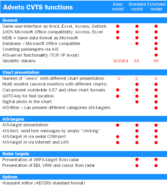
CVTS

CVTS-funktioner
 

Bas-
modell

Standard
modell
l

Extended-modell


Allmänt


Windowsmenyer som Word, Excel, Access, Outlook ….

·

·

·

Databas – Microsoft Office kompatibel


·

·

Passagerarräkning via AIS


·

AIS-server  både TCP/IP in  och ut


·

Geodetiska datum

WGS84

All

All


Presentation av Sjökort


Antal ”vyer” med individuell presentation

1

2

4

Multimonitor (möjlighet till flera monitorer)


·

·

Worldwide S-57 / S-63 Chartworld, , BSB, TX97…..

·

·

·

Egna Digitala foto och anteckningar I sjökortet


·

·

AIS-filter – kan urskilja/bearbeta kategorier i AIS-målen


·


AIS-mål


AIS-presentation

·

·

·

Via serie COM-port eller LAN, TCP/IP, Internet valfritt

·

·

·

Sänd textmeddelanden enkelt med ”högerklick” på målet


·

·


Radar-mål


Presentation av ARPA-target från radar


·

·

Presentation av EBL VRM och markör från radar


·

·

 
Optioner


Waypoint editor   (AECDIS standard format) 

·

·

·


                    ADVETO CVTS

                   Overview and monitor vessels equipped with AIS
                  world wide - an opportunity for marine professionals         


ADVETO CVTS offers an opportunity for land based users to
overview and monitor the movements of AIS-equipped vessels
using the same ECDIS screen background of official ENCs
(Electronic Nautical Charts) as a rapidly growing number of
vessels now are using. The ADVETO CVTS is an advanced
but still easy-to-run PC system developed by the Swedish company

Adveto – a world pioneer in developing systems based
on AIS information.


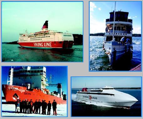
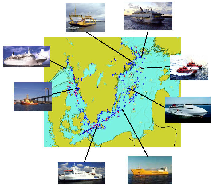
Monitor a variety of vessels equipped with AIS:
m/s Amorella operating the route Stockholm, Sweden -Helsinki,
Finland; m/s Norrskär of the Waxholmsbolaget Line in Stockholm,
a genuine steam ship built in 1910 now operating in the
Stockholm archipelago; m/s Sigyn renowned for handling all of
Sweden’s nuclear transports;
HSC Gotland operating the route Nynäshamn - Visby at the isle
of Gotland in the Baltic Sea.
These are examples of vessels equipped with AIS navigation
systems from Adveto.

From the beginning of 2005 all vessels over 300 gross
tons must be equipped with the Swedish invented AIS
transponder system. Therefore, the movements of not
only all ships over 300 gross tons but also the steadily
increasing number of smaller ships equipped with AIS
can be monitored with ADVETO CVTS. And this applies
world-wide! The only things required are a set of relevant
ENCs, AIS data via Internet, TCP/IP or directly via
an antenna, and an ADVETO CVTS system.

For Port, Harbour and Coastal Authorities, Ship
Owners, Offshore installations and others

The system helps marine professionals and the marine
industry in general to gain benefit from AIS and use the
useful detailed vessel information transmitted and
received. Obvious users are Port, Harbour and Coastal
Authorities, Ship Owners and Marine Managers, Shipping
Companies, Marine Professionals, operators of offshore
installations with vessel monitoring requirements
and all others with a need and interest to monitor vessel
movements all across the world.

A supplement to national VTS systems
The 100% Microsoft Office compatible ADVETO CVTS
system should be considered as a lower cost supplement
to the national VTS systems in use. It is a version
of the well proven and widely renowned ADVETO AECDIS
system aimed for land based users and therefore
excluding the professional navigation functions of the
complete AECDIS-2000 system already in wide use
across the world.

Valuable vessel information on the screen
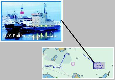
ADVETO CVTS provides a live graphical display of the
vessels on the computer screen on a ENC background
of a detail level as chosen by the user. Both AIS and
ARPA targets can be presented in the chart
automatically. A short presentation of the target is easily
achieved simply by placing the cursor on the target. And
a "single touch" on the symbol activates a true course
and speed vector or predictor. It is also possible to sort
the AIS information on ships name, call sign, IMO number,
distance or speed.

Multiple views
ADVETO CVTS offers up to four different views and the
user can quickly and conveniently switch between the
different views just by the press of a button.
The views might show e.g.an overview of the national
coastline plus details of three major national ports, an
archipelago or inlands waterways. The different views
can also be shown simultanously on separate screens.
Each view can be shown either with the chart freezed or
with the chart picture following a ship’s motion.

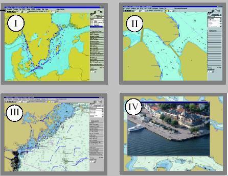
Use official ENCs in CVTS
The growing number of vessels now using official ENCs confirms
the importance of using correct data for safe navigation particularly
in critical and complex waters.
With ADVETO CVTS, land based users now can use the same
official ENCs that are used in professional vessels.
Official ENCs in S57/S63 and Direct-ENC formats from PRIMAR,
IC-ENC and other suppliers can be used in the ADVETO CVTS
and so can all non-official ENCs like Chartworld, BSB raster and
other chartformats.

Additional screen information from separate databases
As a supplement to existing chart information, pictures and
texts can be freely placed in the chart and saved in a database.
By linking e.g. a digital photo to a database point, the picture
can be presented in the chart when the database point is
clicked (view IV above). Several databases can be
run simultaneously.

Passenger counting
ADVETO CVTS offers a feature with reporting of passenger
countings from ships equipped with ADVETO AECTIS-2000.
Provided that staff onboard inputs number of passengers this
data is immediately available in the control center’s CVTS system.
This feature is used onboard all ships of the Stockholm based
Waxholmsbolaget company operating the seagoing public
transport in the complex waters of the Stockholm archipelago
and harbor all year round with some 20 archipelago boats.


Recording

All incoming data to ADVETO CVTS (time, postition,
course, speed, depth, ARPA and AIS targets, etc.) can
be recorded and later used to replay and analyse historical
ship movements. A fast presentation of a 24-hour
recording is available and data for 60-300 days or more
can easily be recorded and saved depending on computer
capacity. Trails from individual targets can be easily
separated from each other simply by applying different
colours.

Easier transmission of text messages
The AIS Text Messages function is still easier to use
with an ADVETO CVTS system: Just place the marker on
the ship symbol, type the message, send it and the
receiving ship can read it on the screen!

AIS filter to select type of ships
The rapidly increasing number of AIS-equipped ships
results in an equally increasing number of ship symbols
shown on the screen.

To facilitate the handling of all this information,
ADVETO CVTS is equipped with an AIS "filter"
making it possible for the user to select the type(s)
of ships to be viewed (passenger, cargo, tank etc.)
or to view ships with e.g. dangerous cargo.
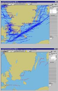

Views
without
AIS-filter


Views
with
AIS-filter


The Swedish company Adveto in Stockholm-Spånga offers the world market
complete digital systems for precision navigation of professional vessels with
official Electronic Nautical Charts. Our user-friendly and
safe world class
systems are developed in Sweden based on, among other things, the special
conditions for
complex navigation in the narrow and shallow waters of the
widespread Scandinavian archipelagos.

World wide usage of Adveto system
Adveto systems are already used all across the world in and around all continents by
work boats, tow boats, ferries and ocean-crossing cruise-liners, pilot boats, skerry boats
and traning ships. The majority of our users are still found in Scandinavia but with a rapidly
growing number of users around the world. In addition to the National Maritime
Administrations in Sweden,Norway and Denmark, the corresponding bodies in Poland, Spain
and Argentina are also Adveto users and so are customers in the harbour of Hong Kong
 and in Mexico - all countries with significant coast lines.
 

World pioneers with commercial AIS solutions
Adveto started in 1987 and understood the benefits of AIS at an early stage.
Already in 1993 we were the first company to produce AIS software for commercial use.
One of our first customers was the Swedish Maritime Administration.
Since then we have frequently added a number of new functions that can be connected
to Adveto’s systems for precision navigation with official ENCs – functions integrated into
ADVETO CVTS.

Complete and safe systems with after-sales support
Our complete systems include hardware, software, NAVcomputers, DGPS and control
units. We take the responsibility for installtion and training directly or via our representatives.
To maximise our customers’ availability of our systems we also give a professional and
comprehensive after-sales support and service. Adveto clients are close partners in our
efforts to constantly improve our solutions.